
| Friends of Five Creeks |
Transforming neglected natural areas, one step at a time. |
|||||||||
|
 Below: on three days of extreme low tides, and during iNaturalist's City Nature Challenge, eers resumed documenting what lives between tides on Albany Beach and bulb, creating a baseline for climate change.
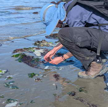
Helping Nature in the East Bay – Hands On
-
Learn more about our work: Subscribe to our e-news to keep up with what our volunteers are doing, Bay Area environmental news, and a "feature of the month." (We don't share your information with anybody.) See maps, history, and slide shows of some of our projects.
Join us at critical planning meeting for Schoolhouse Creek & North Basin Strip 1-3 PM Sun., June 1, at North Berkeley Senior Center
What is at stake: The Sunday, June 1 workshop, 1-3 PM at the North Berkeley Senior Center, is the last public input scheduled before what are effectively final recommendations on the future of 20 acres and a half mile of Bay shore, south of the foot of Gilman Street, west of the busy Tom Bates sports fields, and north of Virginia Extension -- the eroding, often flooded old dump road, now a park trail. The area is part of McLaughlin East Shore State Park, planned and administered by East Bay Park District.
Ideas may be in flux.
- A recent meeting of an advisory committee (mainly interested organizations and groups) introduced new ideas for a phased, low-cost development with lively activities near the busy sports fields in a short time -- a small-boat launch? roller-skating? music? picnics? These ideas could bring citizen stewardship continuing to nurture the rich array of natives that volunteers have established along the shoreline over 25 years. They could allow school mountain-bike teams to care for both site and trails and small challenges they have built over many years. They could bring a Bay Trail spur connection that encourages savoring nature and appreciating both shoreline and the grasslands and trees of the interior. These ideas, which seemed popular and drew many suggestions, are not yet online or public.
- After feedback including from the Park District Board executive committee, there may be less emphasis on two concepts -- one more developed and "hardened" than the other -- and more on "mixing and matching" elements of each/ One pictures a wide, apparently paved shoreline "promenade" with concessions and palm trees and a large, fenced bike-skills area. The other envisions a trail that floods or moves inland as sea-levels rise, with a possible constructed swimming beach.
- The official park plan, written in 2000, calls for a seawall along the waterfront and a waterfront "promenade." Under current rules and East Bay Park District plans, this would have to be defended against rising seas and storm waves essentially forever. Erosion at the recently built Bay Trail spur just south of Albany Beach has already left it a seawall, washed over by logs and debris and storms. At the recent advisory-committee meeting, it was made clear that other elements of the 2000 plan, such as a youth hostel and parking for 350 cars, are no longer being considered.
- Friends of Five Creeks has reported inaccuracies in the online materials and underlying background "expert" documents. For example, cordgrass that could help protect and stabilize the shoreline, shown to be native by genetic tests, is reported as hybrid, harmful to the environment. The gravel beach in the inlet near Schoolhouse Creek , well sheltered from winds, is called a "reference site for a resilient beach that can migrate landward with sea level rise" for areas with no such shelter. The pre-landfill beach at the mouth of Schoolhouse Creek is described as coarse -- but turn-of-the-century photos and documents show it was a long curve of fine sand backed by low dune, similar to Albany Beach today, and the District's geotechnical report says these clean beach sands are still buried there. The modern shoreline to the north, below eroding bluff, is described as "a hazardous shoreline made up of sharp debris and broken concrete." We see no such hazard; much of the beach is gravel or mud.
- To us, it appears from staff and consultants that the Park District has all but decided early on to not "daylight" the mouth of Schoolhouse Creek from its pipe - goal of F5C since 2004. "Daylighting" would provide a scenic overlook at a small salt marsh at the only place, from south Oakland to north Richmond, that people could see a creek flowing into the bay from anything other than a pipe. It also would reduce West Berkeley flooding that already occurs, and is likely to worsen at climate change brings large deluges.
Please attend the workshop and speak for the park you would like to see. Email us at f5creeks@gmail.com and we will send more information on our misgivings. We do not claim to have answers.
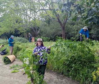
June work party TBA; join our informal, friendly group maintaining varied natural areas every Tuesday
Our June work party will be announced here and in our monthly e-news. Subscribe to get notifications! (We don't share your info with anybody!) Our "Weekday Weed Warriors" gather Tuesday mornings 10 AM - noon. Email f5creeks@gmail.com for more information or to get weekly email notification of locations.
New:
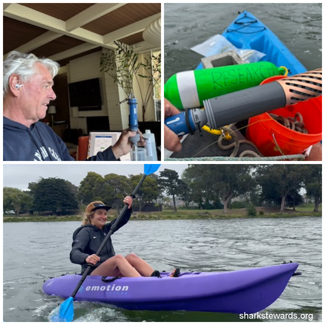
 Ava funding for F5C provides state-of-the-art monitoring for Aquatic Park: On the gray, windy morning of May 24, Shark Stewards' David McGuire and assistant installed a state-of-the-art monitoring device well below the choppy waves in Aquatic Park's main lagoon. It is now recording temperature, salinity, and dissolved oxygen, basic keys to understanding pollution, algae blooms, limited circulation, and periodic wildlife die-offs.
Findings, read every few months using a cell phone, are to be made public and shared with the Berkeley Parks and Public Works Departments. Student interns are to analyze the data as part of preparing for environmental careers. The device was financed with a $2500 Community Stewardship sponsorship for Friends of Five Creeks from AVA Community Energy, Berkeley's green-energy supplier. Big thanks to AVA!
More info in our coming June e-news. For updates and extensive background on the park, see aquaticpark.org, a website we built and maintain to encourage realistic maintenance and correction of the serious watershed problems in this part.
 F5C President a Bay Nature Local Hero -- We are honored that Friends of Five Creeks' longtime president, Susan Schwartz, has been chosen as one of Bay Nature Institute's 2525 local heroes -- "changemakers who, through their passion for the natural world, are making a difference for our precious Bay Area environment." Susan's talk at the April 6 award event is here.
How are our East Bay shorelines changing? Tracking history as climate changes. Click here to view slide show in a new window. This is a large file! Please be patient. It is meant to be viewed on a large screen. Slides are set to advance slowly, for reading and a close look. This is a beginning effort -- please help us build these records!
We are building baseline data on what lives between the tides along the Berkeley and Emeryville shorelines, focused especially on the Albany shoreline from the southwest tip of the Albany Bulb to the sandstone outcrop at Golden Gate Fields. It is best done during spring to fall daytime low tides. If you'd like to help with these citizen-science efforts, please email f5creeks@gmail.com.
We are working with the informal Friends of Aquatic Park to make sure that this new plan, and other city actions, adequately deal with the complex and longstanding issues of water quality and poor circulation in the park's lagoons, as well as new and increasing challenges from climate change. This so far includes building the informative web site aquaticpark.org along with other efforts, from posting signs about how to report problems to developing baseline information on water quality and the sometimes surprising plants and animals that live in the park.
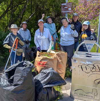
Our interns' survey of woodrat nests, important "ecosystem engineering" in the El Cerrito Hillside Natural Area, is here. El Cerrito's draft final plan for reducing fire risk in the El Cerrito Hillside Natural Area is online here, along with public comments and the consultants' responses. Our interns presented their work at a Dec. 10 joint meeting of the El Cerrito Environmental Quality and Urban Forestry Committees, and may do so again when this plan goes to the City Council. Although the plan has been improved in response to comments, we still have concerns about whether it adequately protects wildlife and habitat, and whether the city is being realistic about the needs and costs for maintenance. (We worked for more than a decade and transformed the main, 75-acre portion of the Hillside Natural area, reducing fire danger mainly by removing French Broom.) F5C's detailed comments on El Cerrito's draft plan for the Hillside Natural Area are here. For earlier comments: Friends of Five Creeks' January input on what this plan should include is here. A short slide show is here. An earlier handout is here.
More handouts, slide shows, and reports
- See our native-plant signs, linking species to their roles in history and the environment. Free to all to download, modify, and use!
- Intern Paulina Lara's guide to how native plants and animals "get along" on Codornices Creek (helpful for other local creeks as well) -- her senior honors project at CSU East Bay. Click here for English or Spanish versions. (These are large files. Please be patient.) It's on display now on the Codornices Creek trail at the net at Sixth Street. See more of our displays on the Codornices Creekside trail: A schematic map of the creek between San Pablo and Tenth Street done by Berkeley High student Evan McMurtrie, "tree trolls" and "tiny things" designed by our interns, at the creekside meadow across from the Little League ballfields, between 10th and 8th Streets, on the Berkeley-Albany border.
- See our flyer on how to de-clutter the environmental way and Saving Water -- Rain or Shine.
- Click here to see our slide show: Codornices Creek, Chapters in an Unfinished History
- Do-it-yourself Nature Treasure Hunt for families with young children. Print out these two sheets back-to-back for fun aimed to engage young children in nature -- along with queries designed to intrigue and challenge adults. This hunt focuses on Codornices Creek, but is easily adapted to other places. You can even use it on a cell phone!
F5C selected older letters to agencies
- Need for toileting and RV sewage pumpout for unhoused in Berkeley: Read F5C's June 2023 letter on the need for portable toilets and sewage pumpout for the unhoused, for human dignity, public health, and pollution prevention.
- Considering likely effects of climate change in Berkeley's plans for development in its Marina area: Read F5C's May 2023 letter on the draft Waterfront Specific Plan.
- Protecting Codornices Creek as part of re-paving the Hopkins-Gilman corridor in Berkeley: Read F5C's February 2023 letters on the importance of including green amenities, pollution reduction, and protection for Codornices Creek in a "complete streets" project for Hopkins Avenue, which follows the creek a half block away. The project was shelved.